Fine Art Prints, Metal Prints, Canvas Art and Acrylic Prints for sale custom framed or unframed to decorate your office walls, home walls, cafe, restaurant, corporate art, boardroom, waiting room or almost any commercial space.
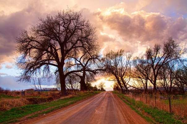
Nothing like taking a dirt road and driving into the clouds at sunset and doing a little sky driving. These are really cool Colorado county roads always good for cruising. Love the trees, the leaves are just starting to bud.. Caught this while out looking for and watching the storms build up. Such beautiful time of year, almost to storm season here on the front range.
Another slow shutter speed exposure scenic long portrait view of some of the waterfalls on the south St Vrain Creek flowing down the south St Vrain Canyon from the majestic snow covered Rocky Mountain Peaks above in Boulder County, Colorado. This is a great ride up to peak to peak highway. If you take this strait up you will go through Allenspark and past the Chapel on the Rock on the way to Estes Park and Rocky Mountain National Park.
Colorado fine art nature landscape photography poster prints, decorative canvas prints, acrylic prints, metal prints, corporate artwork, greeting cards and stock images by James Bo Insogna (C) – All Rights Reserved.
Hanging out in the south St Vrain Canyon, shooting the canyon, creek and water falls. Another beautiful day in Boulder County, Colorado.
St. Vrain Creek rises along the continental divide, west of St. Vrain Mountain. It descends in canyon to flow along State Highway 7 and past Raymond. It joins the shorter South St. Vrain Creek about two miles below Raymond. North St. Vrain Creek rises northeast of St. Vrain Mountain near Allenspark and descends in a canyon to the east along U.S. Highway 36.
The two branches join at Lyons, at the mouth of the canyon. East of Lyons, the combined stream flows southeast through farmland and ranch country, passing south of Hygiene and entering Longmont. It passes through the south side of Longmont where it is rimmed by a greenway trail and several parks. East of Longmont it flows generally northeast, meandering through a wide river bottom in ranch country and passing under Interstate 25 south of the intersection with State Highway 66. It joins the South Platte from the west just upstream from the ruins of Fort St. Vrain and approximately 4 miles northwest of Platteville.
Day in the life of a photographer Bo Insogna, www.MrBo.com